


Le Monetier Les Bains au fil de l'eau

Axelloceane
User
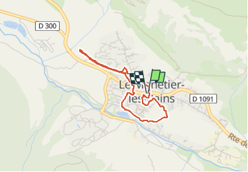

Length
3.2 km

Max alt
1522 m

Uphill gradient
60 m
Km-Effort
4 km

Min alt
1462 m

Downhill gradient
60 m
Boucle
Yes
Creation date :
2025-07-24 09:02:47.117
Updated on :
2025-07-24 10:07:14.002
55m
Difficulty : Easy

FREE GPS app for hiking
 SityTrail
IGN / Geographical institutes
SityTrail Plus
The world is yours!
About
Trail Walking of 3.2 km to be discovered at Provence-Alpes-Côte d'Azur, Hautes-Alpes, Le Monêtier-les-Bains. This trail is proposed by Axelloceane.
Photos


Positioning
Country:
France
Region :
Provence-Alpes-Côte d'Azur
Department/Province :
Hautes-Alpes
Municipality :
Le Monêtier-les-Bains
Location:
Unknown
Start:(Dec)
Start:(UTM)
303624 ; 4983309 (32T) N.
Comments